


9:40 p.m. update: The National Weather Service has canceled the severe thunderstorm watch for most of the area as storms have mostly weakened or exited the area. However, showers and storms are still possible as the cold front comes through between 11 p.m. and 2 a.m., as noted below.
8:45 p.m. update: The severe storms southeast of the Beltway have moved off to the east. Some scattered pop-up showers and storms have developed across the greater DC region. There is still a chance an isolated pop-up turns severe with strong winds or some hail.
Meanwhile, a band of rain and maybe thunder looks to come through between 11 p.m. and 2 a.m. Again, with that band, there is a chance an isolated portion or two of the band turns severe with strong winds and perhaps some hail.
7:35 p.m. update: Severe thunderstorm warnings are currently in effect southeast of the Beltway into Southern Maryland until 8 p.m., including much of southern Prince George's county and most of Calvert County, due to potential for for damaging winds and some hail.
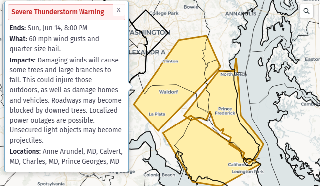
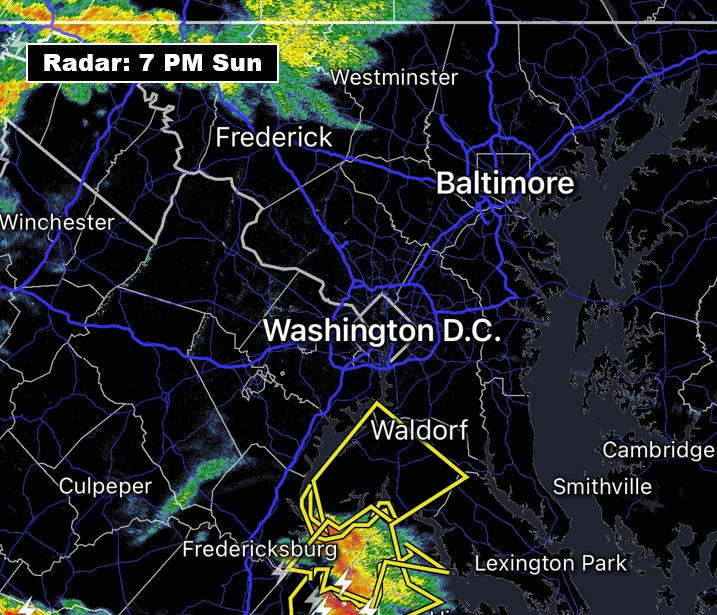
7 p.m. update: Right now radar shows a DC split with storms to the north and storms to the south, including a strong storm currently moving east-northeast into Charles County, where a severe thunderstorm warning covers much of the county until 7:30 p.m. (see yellow warning box in radar image below) due to potential for damaging winds.
This storm is on track to move through parts of St. Mary's, Calvert, and far southern Prince George's counties over the next hour.
It's still possible hit-or-miss storms develop closer to the immediate DC metro area as the evening progresses. We'll keep you posted.
From earlier
With thunderstorms intensifying to the southwest, and an unstable environment over the area, the National Weather Service has placed us under a severe thunderstorm watch until 11 p.m.
The watch highlights potential for wind gusts of 70 mph and hail to the size of ping pong balls. Dangerous lightning is also probable, and a brief tornado can't be ruled out.
A technical discussion released earlier in the afternoon noted the abundant storm fuel present and the likelihood for some wind damage. We anticipate storms to arrive in the Beltway area between 6 and 10 p.m. They may arrive slightly earlier in our far western areas while affecting areas near and east of the bay between 8 and 11 p.m.
Remember that a severe thunderstorm watch means conditions are favorable for severe storms, but not a guarantee. Stay alert. If a severe thunderstorm warning is issued for your location, it means a severe storm is imminent and you should seek shelter immediately.


