Skip to content

Capital Weather Live

Our Forecast & Updates

Always a human at the helm: Updated around-the-clock by Capital Weather meteorologists.

Happening now: Breezy through evening but calming into the night. Mainly clear skies as temperatures fall into and through the 70s on the way to lows in the upper 50s to mid-60s.

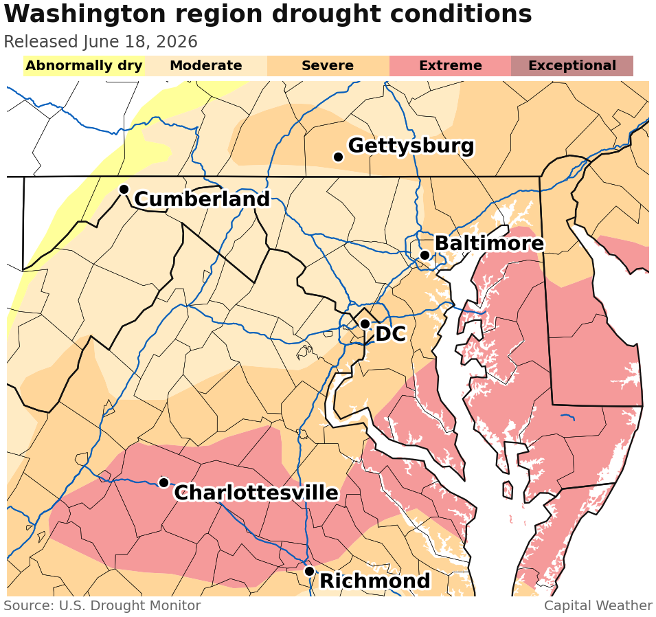
What's next? Rain-free and low humidity this weekend. Saturday 80s before a bit hotter Sunday. Rain chances return Monday but unlikely enough for drought relief, unfortunately.

Forecast in detail

Tonight: Few clouds early, maybe some more high clouds late, and a diminishing breeze from the northwest. Lows in the upper 50s to mid-60s with dry, comfortable air. Confidence: Medium-High

Tomorrow (Saturday): Sunny with pleasantly low humidity. Highs get to within a few degrees of 85. Comfortable for the first weekend of summer — albeit a partial one, since it doesn't arrive until Sunday! Breezes from the northwest may gust around 20 mph. Confidence: Medium-High

Tomorrow night: Mostly calm and clear with lows mainly in the 60s. Confidence: Medium

Sunday: Welcome, summer. Low humidity but hotter highs in the upper 80s to low 90s. High clouds may filter our sunshine by afternoon. Confidence: Medium

A look ahead

Sunday night: Becoming more humid as a warm front passes through the region late. Predawn hours could see a few showers and rumbles, too, possibly disturbing sleep. Lows in the 60s to near 70. Confidence: Medium

Showers and a few possible downpours are back in the forecast Monday. Then we add in thunderstorms during the afternoon and evening. One or two could be strong to severe, with gusty winds possible. Highs in the mid-80s to low 90s. Confidence: Medium

Sunshine returns Tuesday but a lingering shower or storm remains possible. Dry air slowly moves in, making highs in the 80s. Confidence: Low-Medium

Dim, gray skies and a slight reflection on the wet walk around the MLK memorial
Wet pavement at the Martin Luther King, Jr., Memorial, May 24 (Jeanne Stuart McVey/Flickr)

On this day

DC weather history for June 19

A powerful 1944 thunderstorm followed intense heat, bringing record rain, lightning damage, and a sharp cooldown in its wake.

Sunrise5:43 AMSunset8:37 PM
Avg High86°Avg Low69°
Rec High99° 1994Rec Low51° 1909Rec Rain2.01" 1944
Read full June 19 weather history →

Today’s daily digit — 5/10: Cloudy morning with showers in spots. But a nicer afternoon brings drier, comfortable air! | 🤚 Your call?
The digit is a somewhat subjective rating of the day’s weather, on a 0-to-10 scale.

There was no change in the drought classification across the DC area in this week's update from the U.S. Drought Monitor. There was also little to no rain, a defining characteristic of a fourth-driest June to date, one drier than any seen in the District in eight decades.

Extreme drought, the second-worst category from the monitor, increased its coverage somewhat in southern Maryland to now encompass all of St. Mary's County. More of the Delmarva Peninsula also moved into extreme drought, with most of that region now included in that category.

Map showing drought conditions across the region. DC is surrounded by extreme drought, the second to worst category, in the south and east. The city itself is in severe drought.

Despite little official change nearby this week, the situation this month has been far from good news for moving the needle away from drought. DC has picked up only 0.21 inches of rain, which is 2.25 inches below normal, and no June has been drier since 1940, the record holder to date with 0.11 inches.

This comes during a month that is the second-wettest of the year in the District, averaging 4.20 inches from start to finish. And, as Jason Samenow highlighted for friends and founders in Thursday's newsletter, we're missing about a foot of rain over the last year.

Both the more reliable weather models and the experts at the National Weather Service expect precipitation to be at least somewhat above normal over the next week to 10 days.

While the next few days will be largely or fully dry, Monday appears to bring a chance for relatively substantial rainfall — perhaps also strong storms — on the order of half an inch or more for places that cash in.

Keep in mind, the saying goes something like, "When in drought, leave it out," and plenty of recent rain chances have evaporated as their time arrives.

After some showers and storms Friday afternoon, the weather looks fabulous for Friday evening and the weekend at the Maryland and Delaware beaches.

Saturday: Mostly sunny with afternoon highs in the low 80s and fairly low humidity (dew points near 60). A bit of a breeze comes from the northwest and west at 10 to 20 mph. Saturday evening 70s dip to the mid-60s for overnight lows.

Sunday: Mostly sunny with afternoon highs in the low 80s again. Humidity remains on the low side, at least compared to what's typical at the beaches, with dew points in the low 60s. Winds are around 10 mph from the west and south.

Water temperatures: They are currently 65 to 70 degrees. See a live map of regional water temperatures on our Weather Now page.

One thing we're going to keep doing at Capital Weather is continually develop new goodies as we move along. Two big ones were just added to the site:

  • Maps of predicted precipitation. From the premier forecasters at the National Weather Service's Weather Prediction Center, the Forecast Lab now has maps for predicted precipitation amounts, as well as forecast totals for various periods like one to three days or one to seven days.
  • Maps of observed precipitation. New maps in the Climate Room display how much rain has fallen, back to three days. The data originates from the National Severe Storms Laboratory and comes to us from the always amazing Iowa Environment Mesonet site. Coming soon: we'll be adding observed precipitation data going further back in time.
Accumulated precipitation map for the last 72 hours shows a strips near the southern tip of southern Marlyand and from northeast MD to the northeast toward Philly.

Since we launched CapitalWeather.com at the very end of May, some other additions and changes include:

  • Dark mode. Most of the weather and climate widgets have been enabled for dark mode. Any not converted will soon be.
  • Alert map and related items. Dan Stillman and I developed an alert map to accompany our alert widgets. Dan has also led development of our severe weather coverage widgets.
  • Climate Room now includes many more locations. One supporter understandably requested we ditch airport acronyms (DCA, IAD and BWI) for actual names. While making this change, I added a bunch of additional locations, as far away as Salisbury and Hagerstown.
  • Calendar view for monthly data summaries. Based on supporter feedback, I added a color-coded calendar to the Climate Room to summarize days that were warmer and cooler compared to normal, as well as precipitation information.
  • Temperature differences from normal for each month over the last year. While writing a recap of May's weather, I noticed the Climate Room didn't quickly point to how the month compared to normal. So I added a widget which now displays this.
  • Severe weather event summary maps. As soon as we launched the site, storms arrived. We want to be able to remember how much damage they produced for any date, and these interactive maps will help.
Published:
Last updated:

We're so excited you have found us during our preview week. As we work out the kinks this week, we would love your feedback on anything and everything at our new homes – capitalweather.com and on our new Capital Weather app for iOS and Android.

What do you like? What do you not like? What's working well, what isn't working? What are we missing?

We'll keep this post active, to collect this feedback, throughout the coming week.

Published:
Last updated: